GeoAI-Powered Solutions for Sustainable Cities

Spatial Hub is a geospatial technology company specializing in GeoAI, earth observation, and climate resilience solutions. By integrating satellite imagery, drone data, GIS, hydrological and hydraulic modeling, machine learning, and digital twins, we help organizations better understand risks, optimize assets, improve planning, and build more resilient communities and infrastructure systems.

We help governments, infrastructure operators, utilities, and planners transform geospatial data into actionable intelligence through geospatial intelligence, earth observation, climate modeling, and digital twin technologies.

Our Services

Geographical Information System (GIS), Mapping, Geospatial

Geospatial Intelligence

Geospatial Intelligence combines spatial data, analytical methods, and GeoAI techniques to understand patterns, relationships, and dynamics across space and time. It enables organizations to transform complex geospatial datasets into clear, decision-ready insights.
At Spatial Hub, we apply advanced spatial analytics, machine learning, and geospatial data integration to support urban planning, infrastructure management, land administration, and environmental decision-making. This capability forms the foundation for evidence-based planning and intelligent spatial systems across sectors.

Close-up of Soyuz spacecraft orbiting Earth with solar panels extended, showcasing space exploration technology.

Earth Observation

Earth Observation & Monitoring focuses on acquiring and analyzing information about the Earth’s surface using satellite imagery, drone data, and remote sensing technologies. It enables continuous monitoring of environmental, urban, and infrastructural changes without direct physical access.
At Spatial Hub, we transform satellite and drone data into actionable intelligence using advanced image processing, change detection, and AI-based classification techniques. This supports applications such as urban expansion monitoring, environmental assessment, asset tracking, and resource management, enabling organizations to respond faster and more effectively to change.

A group of people wading through a flooded area in Manjhoo Shori, Balochistan, showcasing resilience.

Climate, Hydraulic & Hdrologic Modeling

Climate, Hydrological & Hydraulic Modeling focuses on understanding water systems, climate-driven risks, and environmental dynamics to support resilient planning and disaster risk reduction. It combines spatial data, physical modeling, and GeoAI to simulate and predict natural processes such as rainfall, runoff, flooding, and water flow behavior.
At Spatial Hub, we develop and apply advanced hydrological and hydraulic models integrated with geospatial data and climate information to assess flood risks, design resilient infrastructure, and support climate adaptation strategies. These solutions help governments, engineers, and planners make informed decisions for safer and more sustainable development.

What we do

We develop GeoAI-powered spatial intelligence solutions that transform geospatial, environmental, and infrastructure data into actionable insights for decision-making. By integrating geospatial intelligence, earth observation, and climate modeling, we help organizations understand complex spatial systems, assess risks, and plan more resilient urban and environmental futures.
Our work supports applications in urban development, infrastructure management, environmental monitoring, land administration, and climate resilience.

Domain Applications

Urban Planning & Smart City

Real Estate & Land Administration

Disaster Risk Management

Environmental & Climate Change

Municipal Services & Utilities

Defense & Security

Water & Flood Management

IT & Software Development

technologies2

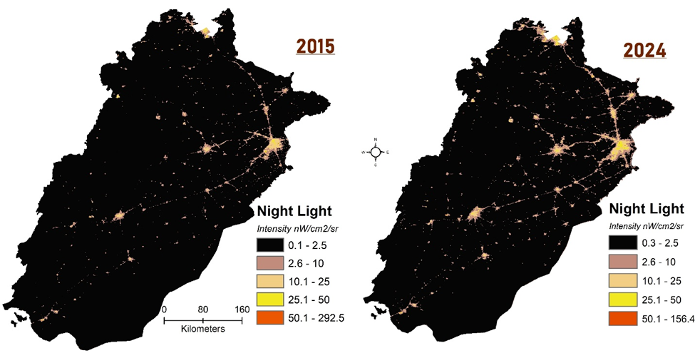
GeoAI & Earth Observatoin to Track Socio-economic Development

image

Ready to Transform Data into Decisions?

_

Count: 749

Scroll to Top