Our Services
Geographic Information Systems
GIS including geospatial mapping and analysis is crucial for determining and understanding spatial relationships and patterns among real world features, enabling informed decision-making across various fields. They allow us to visualize, interpret, and manipulate geographically referenced data to solve complex real-world problems including deforestation, urban development, disasters, etc.
In today’s fast-paced, data-driven world, understanding the relationship between location and data has become crucial for businesses seeking to gain a competitive edge. Whether you’re looking to optimize operations, expand into new markets, or simply understand your customers better, we’re here to help you unlock the full potential of available data as well as GIS data.
By applying the latest geospatial technologies and methodologies, we empower businesses to transform raw location data into actionable insights, enabling them to make more informed decisions, optimize operations, and ultimately, achieve their strategic objectives.
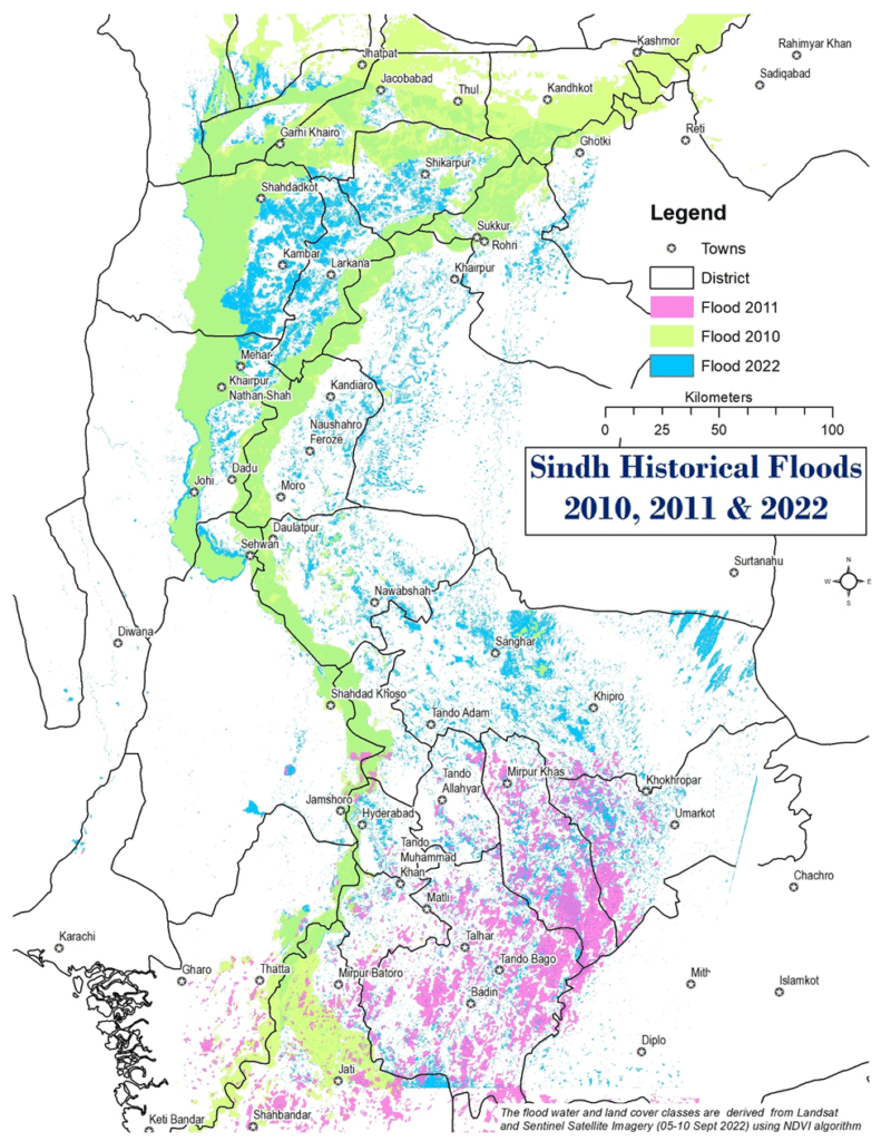
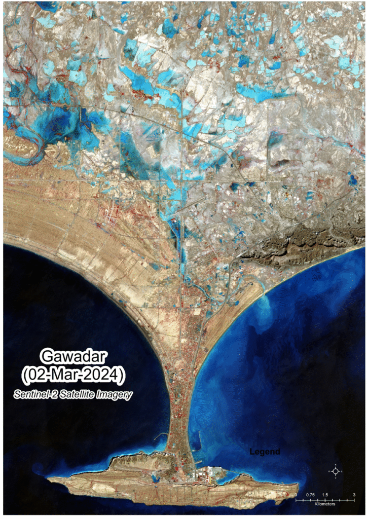
Remote Sensing and Earth Observation
Remote Sensing (RS) and Earth Observation (EO) including satellite or drone imagery analysis and imagery Services are essential for understanding Earth’s surface without direct contact, offering critical data for diverse applications. These services enable monitoring, tracking changes, and informed decision-making across environmental, resource management, and urban planning sectors.
Remote Sensing Analysis and Imagery Services are crucial for gaining comprehensive insights into our planet without direct physical contact. By capturing and analyzing data from satellites, aircraft, and drones, these services offer an unparalleled ability to monitor vast areas, track changes over time, and provide critical information for a multitude of applications.
From precisely monitoring agricultural fields for optimal yield and detecting environmental degradation like deforestation and pollution, to aiding in disaster management by mapping affected areas and assisting in urban planning by tracking growth, remote sensing provides invaluable spatial, spectral, and temporal data.
The RS and EO technology empower informed decision-making across diverse sectors, including environmental conservation, resource management, climate change studies, and infrastructure development, ultimately contributing to more sustainable and resilient societies.
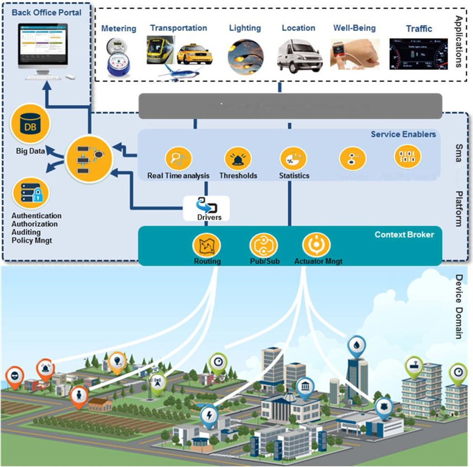
Internet of Things (IoT)
The Internet of Things (IoT) is a transformative technology that connects physical devices—such as sensors, vehicles, infrastructure, and machines—to the internet, enabling real-time data collection, communication, and intelligent decision-making. IoT plays a vital role across multiple sectors by enhancing efficiency, automation, and responsiveness. In remote sensing, IoT enables continuous environmental monitoring (e.g., air quality, water levels, soil moisture) through ground-based sensors, complementing satellite data with real-time insights.
In urban and smart city applications, IoT drives smart traffic systems, energy-efficient infrastructure, waste management, and public safety networks, making cities more livable and sustainable. In agriculture, IoT supports precision farming through automated irrigation, weather-based crop monitoring, and resource optimization. In healthcare, it powers remote patient monitoring and emergency alerts. Furthermore, industrial and infrastructure sectors benefit from IoT through predictive maintenance and asset tracking.
Overall, IoT is reshaping the modern world by enabling smarter systems, improving decision-making, and promoting sustainable development across industries
Training and Consultancy
Our Training, Advisory and Consultancy Services are designed to empower individuals, teams, and organizations with the knowledge and tools needed to excel in geospatial and development-focused projects. With over 18 years of industry experience, we offer specialized training and consultancy in:
Geospatial Trainings: Hands-on training in GIS, remote sensing, spatial analysis, and mapping tools (ArcGIS, QGIS, Google Earth Engine, etc.), tailored to the needs of professionals in environment, urban planning, disaster risk reduction, and engineering sectors.
Report Writing & Technical Documentation: We help professionals develop clear, structured, and impactful technical reports, ensuring their work is communicated effectively to stakeholders, funders, and policymakers.
Concept Notes & Proposal Writing: We guide organizations and individuals in crafting high-quality concept notes and funding proposals for donors, NGOs, development agencies, and research bodies—maximizing the chance of project approval and funding.
Feasibility Studies: We conduct and advise on feasibility studies that assess the technical, financial, environmental, and social viability of projects. Our geospatial expertise adds a spatial intelligence layer, enhancing the depth and credibility of these assessments.
In today’s competitive environment, organizations need more than just data—they need strategic capacity. Our services bridge the gap between technical expertise and actionable communication, helping clients win projects, build internal capacity, and make informed decisions. Whether you’re launching a GIS unit, applying for grants, or evaluating a development project, we provide the guidance and training you need to succeed.

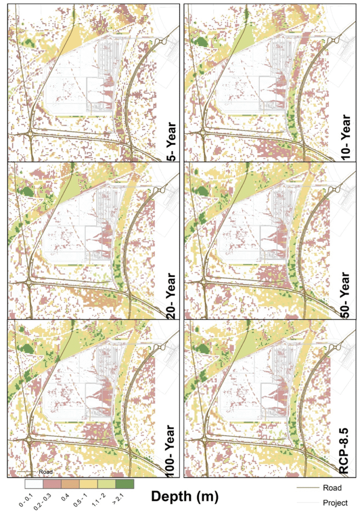
Hydrologic and Hydraulic Modeling
Our Training and Advisory Services are designed to empower individuals, teams, and organizations with the knowledge and tools needed to excel in geospatial and development-focused projects. With over 18 years of industry experience, we offer specialized training and consultancy in:
Geospatial Trainings: Hands-on training in GIS, remote sensing, spatial analysis, and mapping tools (ArcGIS, QGIS, Google Earth Engine, etc.), tailored to the needs of professionals in environment, urban planning, disaster risk reduction, and engineering sectors.
Report Writing & Technical Documentation: We help professionals develop clear, structured, and impactful technical reports, ensuring their work is communicated effectively to stakeholders, funders, and policymakers.
Concept Notes & Proposal Writing: We guide organizations and individuals in crafting high-quality concept notes and funding proposals for donors, NGOs, development agencies, and research bodies—maximizing the chance of project approval and funding.
Feasibility Studies: We conduct and advise on feasibility studies that assess the technical, financial, environmental, and social viability of projects. Our geospatial expertise adds a spatial intelligence layer, enhancing the depth and credibility of these assessments.
In today’s competitive environment, organizations need more than just data—they need strategic capacity. Our services bridge the gap between technical expertise and actionable communication, helping clients win projects, build internal capacity, and make informed decisions. Whether you’re launching a GIS unit, applying for grants, or evaluating a development project, we provide the guidance and training you need to succeed.
Ready to Transform Data into Decisions?